Thursday 14 November 2019

Bayston Hill, Shropshire - Largest Population of Any Village in County History and Information


Bayston Hill, Shropshire - With the Largest Number of Residents of Any Village in the County History and Facts

Bayston Hill has the Largest Population of Any Shropshire Village.

With over 5,000 residents in the 2011 census Bayston Hill is Shropshire's most populated village.

At just 3 miles from Shrewsbury centre it is easy to think of it as a dormitory village, but it has origins in the middle ages, borders on lovely Shropshire countryside, has 3 pubs, 2 churches, schools and a public library.

Lyth Hill to the south of the village is within walking distance from the centre, and is a major Shropshire attraction, especially for dog walkers, with open views to south Shropshire from the public parkland which follows top of the escarpment along the hillside.

There is remaining evidence of both an ancient British Iron Age hillfort and a Roman settlement located on the village's high grounds.

In the Middle Ages the heavily wooded Bayston Hill and Condover area was established as a Royal hunting forest. A busy rope works, complete with its own windmill built in 1835, existed on Lyth Hill in the 19th century.

The rope industry supplied the many mines, farms, and barge owners of those times in this area. A church was built alongside the village glebelands in 1843 to serve the local miners, quarrymen and railway navvies.

Standing on the south east side is the village's oldest archaeological site: a mounded Iron Age bivallate hill fort.

It's relatively low lying for such a structure and oddly named with the Danish name of The Burgs, but probably was not called that until sometime between the 14th and 16th centuries.

The village was surveyed for the Domesday Book during the year 1086, when it was called Begestan, and William Pantulf, an Anglo-Norman nobleman, held land there.

Image shows Thumbnail for the article image about Bayston Hill Shropshire.
One final odd fact to ponder about Bayston Hill is that although the railway runs right past the village, Bayston Hill has never had its own railway station.

If you found this video interesting, encourage me to make more, by "Liking", and "Sharing" it.

This presentation contains images that were used under a Creative Commons License. Click here to see the full list of images and attributions:

https://link.attribute.to/cc/501568
_____________
Watch this video on YouTube here:
https://youtu.be/pNxc0ZI0FqI
_____________

Wednesday 6 November 2019

Bishop's Castle Shropshire and the "Old House on Crutches"


Bishop's Castle is a small market town in the southwest of Shropshire, England, and formerly its smallest borough.

Bishops Castle was one of the so-called Rotten Boroughs. A Rotten Borough was a borough where, prior to the Reform Act 1832, there were very few voters and one person or family could exert undue influence over the election of an MP. According to the 2011 Census it had a population of 1,893.

Bishop's Castle is close to the Wales-England border, and about 20 miles south-west of Shrewsbury.
The original castle is now no more than a few stones, but then it was very old, having been first built in 1127.

The town stands on the edge of Clun Forest.

It is 500 feet above sea level and surrounded by hills, the highest of which rise to 1,500 feet.

Walk around town, and you will see Tudor Houses, the Old Hall square, the Old Market Hall Square, and the Old House on Crutches.

The Old Market Hall, coat of arms is still in the square. The original building was erected by Lord Clive of India circa 1770-1775 but demolished in 1951.

The Powis Coat of Arms which was on the original building has been saved and is the centrepiece of this little square. The Old House on Crutches gets its name from the overhanging upper storey which is supported by posts.

A View of the old Bishop's Castle Shropshire and the "Old House on Crutches".
The Town Hall is one of the smallest in England, and exhibits 2 silver maces hallmarked 1697.

The Three Tuns Inn dates back to 1642, and is the oldest licensed brewery site in Britain.

We hope you enjoyed these facts and the pictures of this lovely little Shropshire town.

If so, please like and share this video to encourage me to make more.

Acknowledgements to: bishops castle shropshire england, bishop's castle shropshire, Bishops Castle.

Saturday 26 October 2019

Mitchell's Fold Stone Circle | Bronze Age Stones The Dun Cow & King Arth...


Mitchell's Fold is a Bronze Age stone circle in southwest Shropshire, located near the small village of White Grit on dry heathland at the southwest end of Stapeley Hill, at a height of 1083 ft (330m) o.d.

It is a Scheduled Ancient Monument (number 107448) in the guardianship of English Heritage.

As with most sites of this type, its true history is unknown.

In the beginning there may have been some thirty stone pillars. The survivors that still stand range in height from less than a foot high to just over 6 feet.

They stand in an ellipse 27 metres, NW-SE by 25 metres.

The tallest is at the south-east end of the major axis, standing, perhaps by coincidence or design, close to the line of the southern moonrise.

This pillar and a companion may have flanked an entrance about 6 ft wide.

There is a traditional folk story that a giant had a marvellous cow which gave unlimited amounts of milk.

The giant's cow grazed the area where now stands the circle, until a malicious witch milked the cow using a sieve.

She continued milking until the cow was drained dry, as a result of which it fled to Warwickshire, where it became the Dun cow.

As a punishment, the witch was turned into stone and surrounded by other stones to prevent her escaping.

What became of the giant is unknown.

Local folklore also suggests this is the actual place where King Arthur withdrew Excalibur from one of the stones in the circle, and then became King of the Britains.

(But there does not appear to be any evidence of this.)

We hope you enjoyed our video, and if you did, please like and share it and if I'm encouraged by the response I'll make more videos about Shropshire! Text Source: Wikipedia.

________________________________
Attribution:
This presentation contains images that were used under a Creative Commons License. Click here to see the full list of images and attributions:
https://link.attribute.to/cc/472813
________________________________
View this on YouTube here:
https://youtu.be/TEjGA0vNYbc

Thursday 15 August 2019

The Humphrey Kynaston Story Shropshire's Robin Hood - In a Nutshell!


Shropshire's Robin Hood

From 1491 to 1518, "Wild Humphrey Kynaston" supposedly lived a life that would closely match the fictional character Robin Hood.

His cave still exists and can be visited in Nesscliffe Hill Country Park.

It seems he had a reputation for robbing from the rich, and giving to the poor.

In return, the locals protected him, and gave him and his horse ('Beelzebub') food.

The cave is in the woods above the original A5 which went through Nesscliffe village here, and was still an important route in Kynaston's time.

The road was built by the Romans as the route from London to Holyhead, and Ireland.

Once, in an attempt to capture him, the local sheriff removed several planks from the Montford Bridge, to keep him from crossing the River Severn.

But his horse managed to leap and safely clear the distance.

It is also said that he was a regular patron at the Old Three Pigeons tavern in Nesscliffe village.

They say his original seat is still there.

On 20 December 1491, Kynaston was found guilty for the murder of John Hughes at Stretton, and declared an outlaw by Henry VII.

Some time after that, he moved from Myddle castle to a cave in Nesscliffe Rock.

Image is the featured image for The Story of Humphrey Kynaston video.
The cave has only two rooms; he lived in one, and stabled Beelzebub in the other.

Some sources claim that the reason he moved was due to the criminal charges, and others claim that he was outlawed due to debts.

He may have been pardoned by Henry VII in 1493, but some say that in 1513, Humphrey provided 100 men to aid Henry VIII in France, and in return received a royal pardon 3 to 5 years later.

If it wasn't for his "outrageous" lifestyle, you would not expect him to have been short of money.
He was the youngest son of Sir Roger Kynaston, High Sheriff of Shropshire, and he inherited Myddle Castle from his father, but allowed the estate to fall into disrepair.

While the year of his death is well known, how he died and where, are disputed.

Some sources claim he lived comfortably in an estate near Welshpool until he died, and others claim he died of illness in his cave.

Source: Wikipedia

Sunday 4 August 2019

Secrets of Shrewsbury Coalfield - Forgotten Coal Mines Bayston Hill, Sutto...


The Shrewsbury Coalfield

Most people know there were mines at Snailbeach, and some can remember being able to see opencast mining taking place beside the M54 near Telford, within the last 35 years.
It's not so well-known that there were at least a dozen mines in what's known as the Shrewsbury Coalfield.

The Shrewsbury Coalfield is situated to the south and south west of Shrewsbury and is small by national standards.

Online sources list mines in the Shrewsbury Coalfield from Asterley in the south west, to Bayston Hill on the east.


  • Longden (the Black Lion Colliery)
  • Meole Colliery
  • Nobold Colliery
  • Sutton Colliery
  • Welbatch Colliery (between Hook-a-Gate, and Annscroft).

Plus, mines at Hanwood, and Pontesbury.

We could list many more, and people watching this may comment on many other mine locations as well.

The mines would have for many centuries supplied the domestic market of Shrewsbury, with the first being "bell pits", dug by hand where coal seams were evident from the surface.

Shrewsbury Coalfield was also important throughout the 18th and 19th centuries, to supply the nearby led mining area to the south, with coal for smelting. In the 19th century, there were 9 reasonably sized collieries and many smaller ones.

By 1921, these had all closed except for Hanwood Colliery which continued for a few years more, until its closure in 1941.

The was also a colliery at Pontesford which had a steam engine installed in 1793 for pumping out water.

In 1811 it appears that the shaft was 225ft deep, and evidence remains in the form of part of the steam pump engine-house, now converted as part of a modern home.

Image introduces the Shrewsbury Coalfield and various mines.
The images shown in this video show typical mines of the period.

They are to provide visual interest, and do not depict the mines referred to.

Text sources: Shropshire History website, and the Northern Mine Research Society.

Image Attributions with Links:
This presentation contains images that were used under a Creative Commons License. Click here to see the full list of images and attributions:

https://link.attribute.to/cc/372105

Watch this on YouTube here.

Sunday 21 July 2019

Castle Pulverbatch Norman Motte and Double Bailey Castle, Scene of Marau...


Castle Pulverbatch Motte and Bailey Castle, Shropshire

Pulverbatch, Shropshire is a pleasant village on the minor road which takes the most direct route to the Long Mynd from Shrewsbury centre, passing through Longden and climbing onto the Mynd, after the hamlet of Bridges.

Here are the remains of two motte and bailey castles, both are scheduled ancient monuments about 1,000 years old.

Norman Invasion

They were needed when in 1066 a Norman expedition from France invaded and conquered England.

The Norman dynasty established by William the Conqueror, ruled England for over half a century and his successors beyond, and was disliked by all, and hated by many.

The Welsh Marches is said to have the highest number of motte and bailey remains in the UK.

The Normans Were Unable to Conquer the Welsh

Most likely this was due to the inability of the Normans to conquer the Welsh, resulting in frequent incursions by marauding Welshmen at that time.

Pulverbatch Motte and Bailey Location and Features

Castle Pulverbatch motte and double bailey castle is situated on a ridge to the south of Pulverbatch village.

It overlooks the village, and the ancient valley route, from Shrewsbury to Bishops Castle (now a green lane at this point).

Roger Venator - Invader Who Took Over the Castle

The manor of Castle Pulverbatch was held by Roger Venator in 1086,  and it's likely he built the castle.

The castle is first mentioned in 1153, but it was not used for long, probably not even for 50 years.

What You Will See if You Visit Pulverbatch Castle (Motte and Bailey)

Image showing Castle Pulverbatch Norman Motte and Bailey Castle, Scene of Marauding Welsh Attacks.
The castle earthworks include a castle mound or motte.

There were once two baileys, and there are still substantial ditches, mounds, and banks to explore.

On the south-east side, the natural hills lope was cut back, to create a defensive steep scarp slope.

A ditch runs along along the western side of the north-east bailey.

The castle has an extensive view over the surrounding countryside, and would have been particularly easy to defend.
Visit and explore! (There is a car park.)

Watch this video on YouTube at: https://youtu.be/ufbyxMpAh84

Text sources were: http://www.pulverbatch.org.uk and https://en.wikipedia.org/wiki/Motte-and-bailey_castle

Saturday 20 July 2019

The Iron Bridge, Ironbridge in the River Severn Gorge, UK


The History of the First Ever Iron Bridge in the World

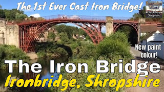
The newly restored Iron Bridge in Ironbridge a presentation style video of the heritage bridge in Shropshire, UK.

The Iron Bridge is a beautiful and historic bridge that crosses the River Severn in Shropshire, England, dating back to the industrial revolution.

Opened in 1781, it was the first major bridge in the world to be made of cast iron, and was greatly celebrated after construction owing to its use of the new material.

Not Used for Road Vehicles Since 1934

In 1934 it was designated a Scheduled Ancient Monument and closed to vehicles.

Tolls for pedestrians were collected until 1950, when ownership of the bridge was transferred to Shropshire County Council.

It now belongs to the local council Telford and Wrekin Borough Council, and has recently been restored into the glorious rusty-red colour which it had when first built.

Part of the the UNESCO Ironbridge Gorge World Heritage Site

The bridge, the adjacent settlement of Ironbridge and the Ironbridge Gorge form the UNESCO Ironbridge Gorge World Heritage Site.

Image showing the thumbnail image of the Iron Bridge, Ironbridge, Shropshire.
The bridge is a Grade 1 listed building and a waypoint on the South Telford Heritage Trail.

Visitors travel from all over the world to see the bridge, the gorge and the renowned museums of the small town which remains.

Text source: Wikipedia with addtions.

Watch this on the YouTube site at: https://youtu.be/gANEbFi-h3I

It's amazing that this Iron Bridge in Ironbridge, was the first ever Iron Bridge in the World. It is located near Telford.

Paint Colour Was Grey/Blue and is Now Reverted to the Original Rust Red!

It was previously restored in 1980 and they didn't do a bad job at that time. The Ironbridge Gorge World Heritage Site now has a Management Plan which is placed under regular review every ten years

Just down the road is the Museum of iron operated by the ironbridge gorge museum trust (museum).